
By Philip Kiefer
If you were to unravel the Chesapeake Bay shoreline, to smooth out every river mouth and tidal basin, it would stretch from New Jersey to Miami. This twisted shoreline, and the marsh behind it, is part of what makes the Chesapeake so productive: It’s an entire universe for young fish and crabs, a constellation of places to hide when soft and feed when hungry.
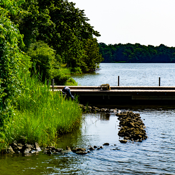
A living shoreline at SERC’s Cheston Point. (Credit: SERC)
And it’s disappearing quickly. Anywhere from half a foot to 10 feet of Chesapeake marsh erode every year, depending on which shoreline you’re standing on. Lost marshes mean lost habitat for migratory birds, molting crabs, and young rockfish. Hundreds of islands have disappeared from the Chesapeake Bay in the last century, leaving behind tidal mudflats, sandbars, or open water.
Erosion eats human habitat too, so we’ve become experts at holding back the water. But many of our techniques for doing so are even worse for coastal ecosystems than unchecked erosion. Retaining walls and armoring stone (sometimes called riprap) hold back the waves, but provide little shelter for animals that live at the shoreline, like young rockfish and blue crabs — a problem called “shoreline hardening.”
So when the Smithsonian Environmental Research Center decided to save a piece of disappearing marshland on its own property, scientists had to take a more creative approach to preserve both soil and habitat.
Reviving Cheston Point
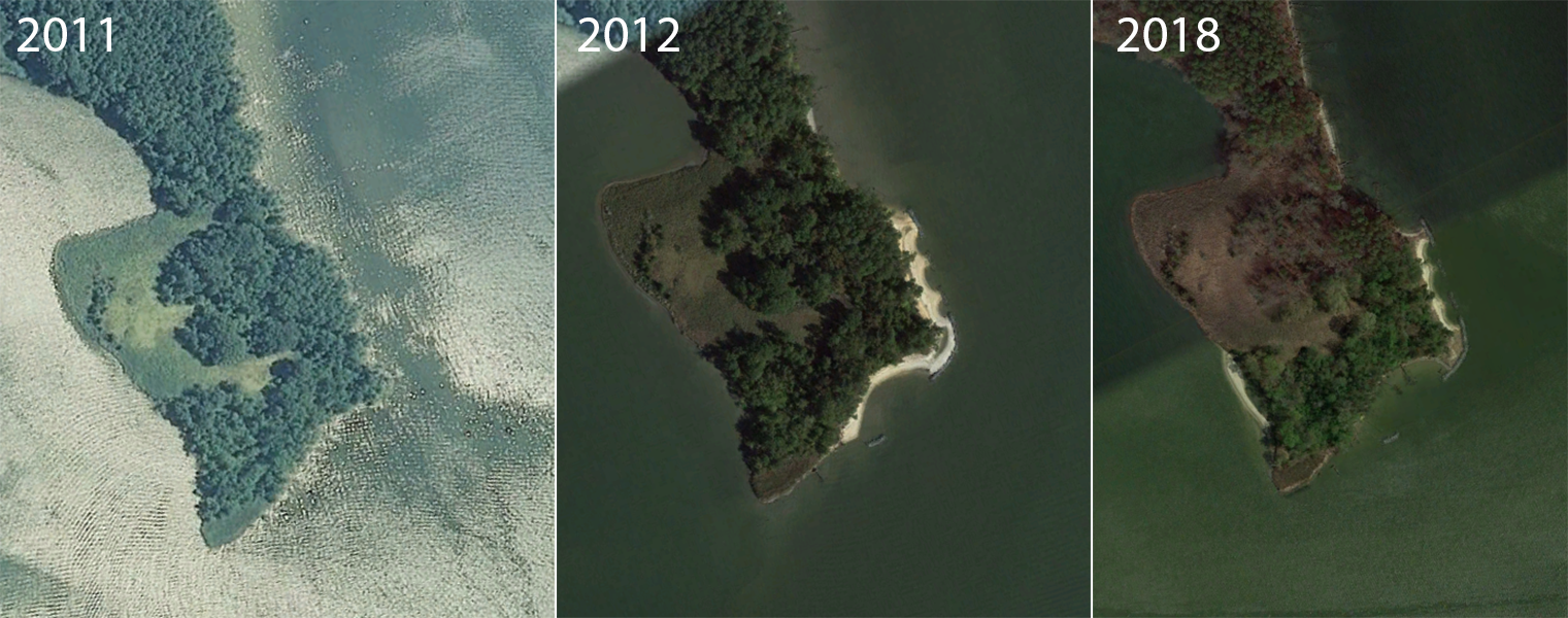
Cheston Point, on the southern end of SERC property, was disappearing rapidly in 2011. It’s at the mouth of the Rhode River, exposed to the full erosive force of the Chesapeake Bay, with its boat wakes, winter storms, and rising tides. Cheston Point is also a rare patch of undeveloped forest and marshland. Just across the river, the shoreline is dotted with marinas and private docks.
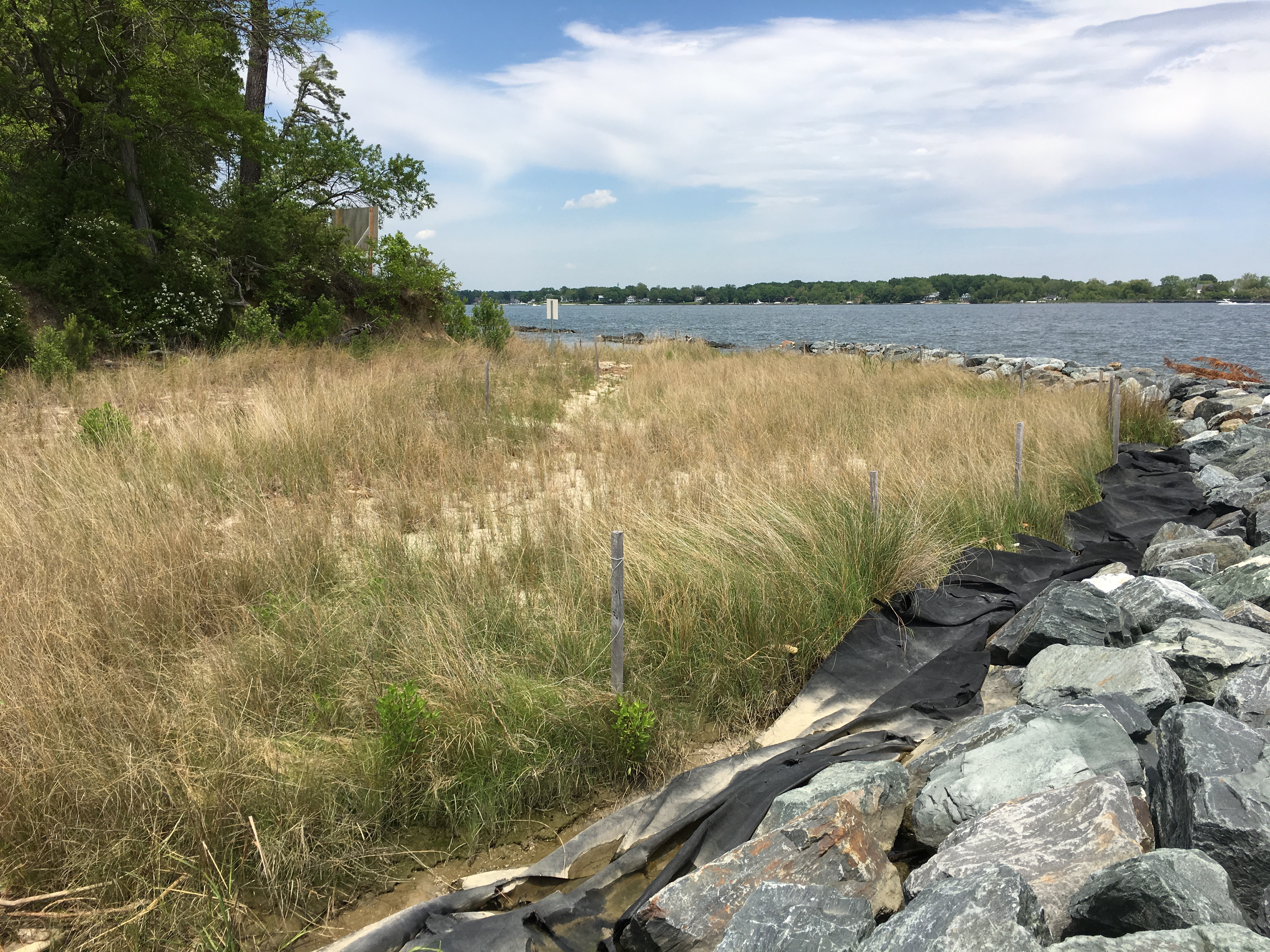
In 2012, SERC began to protect the point with money from the Environmental Protection Agency and the state of Maryland. But rather than just shore up the land with a bulkhead, SERC scientists engineered what’s called a living shoreline. Sam Benson, the SERC marine operations manager who led the restoration, says that with a living shoreline, “you’re effectively armoring the shore, but creating new shallow water habitat in the process.”
Sam Benson and I took a boat out to visit Cheston in mid-July. The Cheston Point restoration is now about halfway complete, and salt marsh has begun to reestablish itself. A sandy beach now stretches into the water from the eroded forest edge. Herons fish in the salt grass at the water’s edge. “We’ve reclaimed part of the river,” says Benson.
The shoreline of Flat Island. (Credit: SERC)
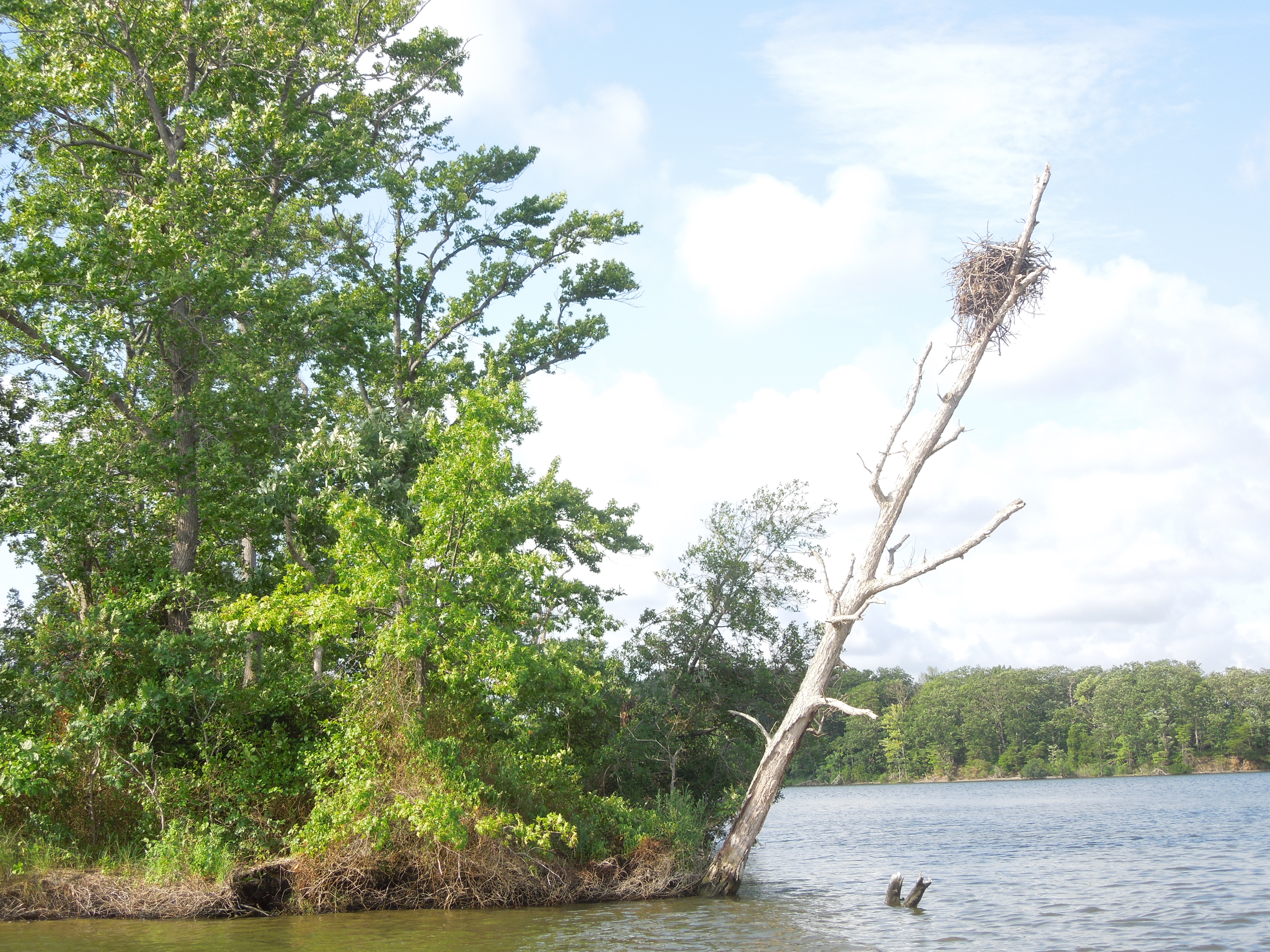
It’s clear what would have happened to Cheston Point without intervention. Further up the Rhode River are a pair of islands, Big Island and Flat Island. Big Island is visibly eroding: The forest on top drops away into sheer cliffs, which are slowly being undercut by the waves. Flat Island is almost gone, just a low-slung rise of trees poking out of the water, which prompted SERC to launch a “Save Flat Island” campaign in 2016.
And the pair used to be a trio. When Pat Megonigal, principal investigator of the SERC Biogeochemistry Lab, first arrived, High Island was a popular spot to moor boats. But, he says, “people loved it to death.” Sam Benson and I rode a boat over what remains of High Island on our way to Cheston Point. High Island still shows up on Google Maps, but only as a submerged sandbar.
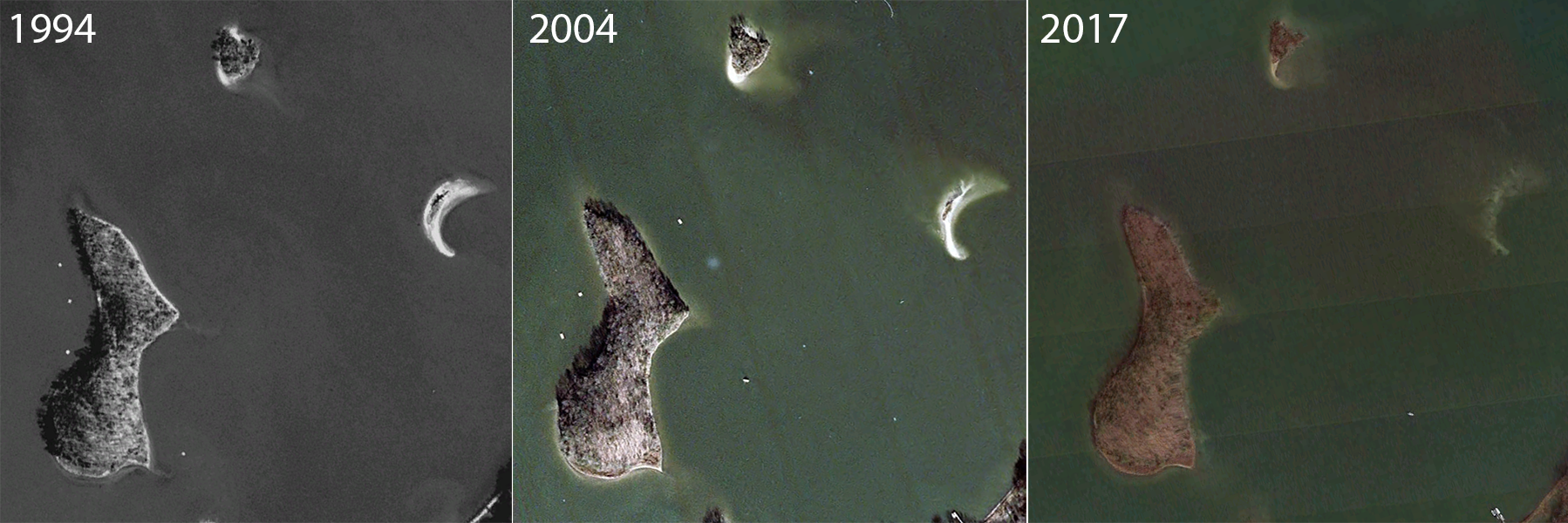
High Island, on the right side of these images, has disappeared over the last 20 years. Flat Island and Big Island are likely next. (Credit: Left and Center, USGS, Right, Google Earth)
Without armor against the waves, Cheston Point would become an island, then a smaller island, then a mudflat, and finally an open patch of water. “There’s a 5-acre marsh that disappears if this point disappears,” says Benson. “That’s acres of natural shoreline in a part of the Chesapeake that doesn’t have a lot left.”
Engineering Marsh
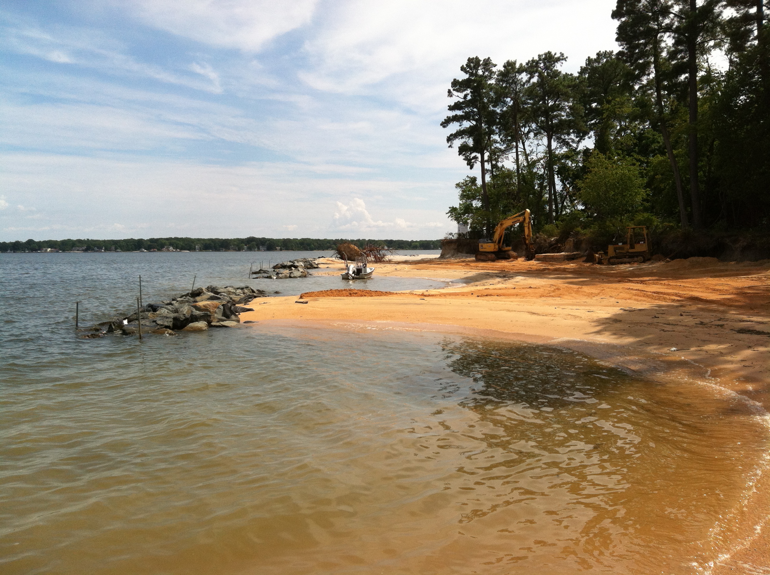
Living shorelines are relatively rare in the Chesapeake, in part because reconstructing marsh is much harder than washing it away. You can’t rebuild shoreline by dumping sand where it used to be, sandcastle style – it’ll erode as fast as you can put it down. When the Army Corps of Engineers began a large-scale restoration project in the mid-’90s on Poplar Island, about 20 miles southeast of SERC, they spent nearly 10 years perfecting their technique before plowing ahead with construction.
The process begins by engineering a patch of calm water where sand might linger enough for grass to grow. Then, the grass has to be coaxed into growing. Shoreline is a surprisingly fragile thing.
At Cheston Point, boulders are lined up several yards offshore, slowing the waves before they reach shore. In the sliver of still water, SERC replaced sand dunes that had been washed away. Salt grass – native Spartina – slow the waves even further, and provide habitat for the small things that live in shallow water, like the rockfish and crabs. Each Spartina plug has to be planted by hand – at SERC, the work was done by an army of citizen scientists. But once planted, they capture and create soil, letting the marsh expand further out into what was once saltwater.
Offshore rocks protect sand from erosion. (Credit: SERC)
There’s also a dusting of invasive Phragmites grass, which colonizes disrupted marshland. Even in an engineered shoreline, some things can’t be controlled. Removing the invaders is “a losing battle,” according to Benson. Phragmites is poor habitat for many types of animals, he says, but Megonigal adds that Phragmites may be good at holding the soil together.”
Despite extensive management of the shore, the sea is ready to reclaim what it’s lost at a moment’s notice. There are gaps in the armor to let the tide wash in and out, and the strength of the waves can be seen through the holes. The unarmored shoreline arcs inland. When viewed from above, it’s clear that something’s been gnawing at the shore – it has the exact shape of a shark bite.
Although the restoration in 2012 visibly reclaimed beach on Cheston Point, erosion continues to wear away unprotected areas. (Credit: Left and Center, USDA Farm Service, Right, Google Earth)
The project is currently about halfway complete, waiting for a second round of funding, and the ocean is obviously carrying away whatever it can in the meantime. On the southern tip of the point, which has yet to be armored, a wide bay has formed, full of downed trees. Benson says their roots have been undercut by water. They’ve died in the salt, and now lie in a tangle on the shoreline.
Saving the Coast in a Time of Rising Seas
The Cheston Point restoration won’t last forever – it was planned to survive about 75 years from the outset. There’s just no way to hold onto marshland permanently in the Chesapeake without more drastic measures.
To the right of this breakwater: waves. To the left, still water. (Credit: Philip Kiefer/SERC)
The idea is not necessarily to preserve the shoreline in its current state in perpetuity, but to fight human impact with human engineering. Cheston Point would wear away naturally, but the process is sped along by modern technology. On a clear day at the end of the point, you can see the Bay Bridge across 10 miles of open water. When I visited with Benson, a line of cargo ships stretched from the bridge to the southern horizon, all headed to Baltimore harbor. The wakes from these behemoths echo down the main channel of the Chesapeake, and crash straight against Cheston Point. They’re joined by the waves from winter storms and summer power boats leaving local marinas.
A century ago, Cheston Point “would have been wearing away with the nor’easters,” says Benson, “not every Saturday and Sunday.” The waves from the ships might be smaller than a storm surge, but Benson says that because they’re constant and come from the same direction, they cause more damage in a less spectacular fashion.
And waves can be fought off, but sea level rise and a phenomenon called glacial subsidence cannot. North America is still responding geologically to the last ice age, which ended about 12,000 years ago. During that ice age, the ice pressed down on a section of North America stretching to Pennsylvania, and the warmer regions rose in response.
“It’s like when you squeeze a balloon on one end,” says Megonigal. “The other end expands, and then contracts when you let go.” Now that the ice has receded, the once-frozen north is rising, while the Chesapeake is slowly sinking. Couple that with rising sea levels, and you have an estuary that is disappearing underwater nearly twice as fast as the average U.S. Atlantic coastline.
Marshes on the Move
This sea level rise is, in the long term, an even larger problem than erosion. The marsh that is restored now will likely be below sea level in a century – erosion control can’t stop the tide. At Poplar Island, the Army Corps of Engineers have rebuilt over a thousand acres of marsh using dredge material. But because most of the island is just 6 feet above sea level, it may wash away again. Just across the bay from SERC, the U.S. Fish and Wildlife and partners are spraying mud onto Blackwater National Wildlife Refuge to raise it above the water, but it’s an expensive undertaking.
There is good news, though. According to Benson, it’s become harder to get a permit to put in a seawall or other shoreline-hardening features. It’s much easier, in terms of land-use permits, to construct living shorelines like the one protecting Cheston Point.
And although hundreds of square miles of marsh have eroded away in the last century, a new study suggests that a roughly equal number have been created. This happens because as seas rise, they don’t simply swallow nearby marshes. Instead, marshes can migrate farther inland—if they have room. The marsh doesn’t necessarily disappear under the ocean; it can march along in front of it. Still, inland development and hardened shorelines can lock the marsh into place, to be drowned when the ocean rises.
It takes a long time for a marsh to expand inland. Extending the lifetime of existing marsh, even by 75 years, might preserve the ecosystem long enough for new marsh to establish itself farther upland. According to Benson, “success depends on your timescale.” Saving the marsh in the long-term, though, will require more than just preserving shoreline. If we want coastal marshes to survive, we also need to protect the farms and pastures that could become marsh in the next century. Around the Chesapeake, ground doesn’t stay solid long.
