by Quinn Burkhart
We’ve known for years that many of Earth’s forests are dying out and struggling to replenish their populations. At the Forest Global Earth Observatory, or ForestGEO, scientists are attempting to get to the root of this issue. A global network of research sites and scientists, ForestGEO studies how climate change is affecting tropical and temperate forests globally. Worldwide, ForestGEO examines how forests are changing over time at 67 sites in 27 countries. This totals to about 12,000 species and six million trees.
The Smithsonian Environmental Research Center (SERC) joined ForestGEO in 2007, having produced their own tree data since 1980. The first two censuses in the 16-hectare plot occurred in 2011 and 2014. In the 12 years since they joined the plot has grown to 40,000 stems, many of which are expected to see rapid health changes in this summer’s census. These changes are widely expected to show decline.
The sour reality of climate change is that more than coastal cities are feeling the heat. Temperate and tropical forests alike struggle to adapt as weather patterns rock their roots. Scientists are scrambling to measure the health of our forests before the trees’ development completely changes. ForestGEO’s primary goal is to compare and contrast how different forests are reacting to changing environments at each site. Despite the near 40 years it’s been since ForestGEO’s founding in 1980, the network is just getting started.
A pioneer organization for forest research, ForestGEO has a big audience to please and lots of measurements to find. In between censuses (done roughly every five years), ForestGEO partners around the world find time to compare each other’s plots.
“Five years is a pretty good time length, because you’ll see a lot more changes to the plot’s health,” said Jess Shue, a technician at SERC in the campus’s plot census. “The accuracy of our tools and calculations is only so good, so five years also gives us time to develop our project further before we return out to the field”.
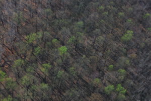
Although future censuses are only prediction right now, SERC scientists expect this summer’s census will be the beginning of serious health decline for the forest. In 2014, the plot contained over 43,000 stems. More than 10,000 were already dead. The team measures both living and dead trees for a proper growth ratio, but it was still upsetting to see so many gone. Shue believes there will likely be even more gone this year, and in the next few censuses the health will plummet. Worldwide, some plots see more or less change than others, but many clearly display decline in each census.
What’s All the Chatter About?
What happens in between those censuses is where ForestGEO makes much of its magic. Like other Smithsonian-based networks, such as the Marine Global Earth Observatory (MarineGEO), consistent communication is key.

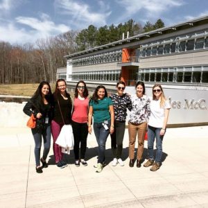
Scientists pose for a group photo outside the Mathias Lab in 2017, during a discussion about the census. Photo: ForestGEO
Sean McMahon is the Temperate Program Coordinator in ForestGEO, and a principal investigator at SERC. He and Shue are responsible for communication between SERC’s ForestGEO branch and the other temperate sites.
“Every summer, we have a two-week workshop at the end of June. Everyone has to apply, and the setup of the workshop is split into several different ‘idea groups,’” Shue explained. “The main objective of this is so when we’re done, we have ideas.”
Although seats for the gathering are limited, many principal investigators often make it, giving ForestGEO a good position from which to continue. It also provides extra in-person time for the multitudes of scientists involved to catch up and ask questions.
Tracking the worldwide health of different forests is invaluable to environmentalists. The logging industry and changing climate alike are transforming the makeup of the forest quicker than we could tell if we couldn’t watch their growth in real time.
ForestGEO enables scientists to collect health data and share it extraordinarily quickly, and provides the ability to make patterns comparing trees to climate.
One Stem at a Time
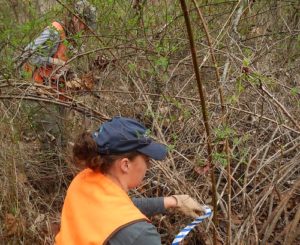
SERC’s plant census takes place in late July and early August. Generally, about a dozen scientists and volunteers take to the field every day and measure every stem they can find. Often, Shue commented, many more trees than expected have died and covered up other surviving stems. This makes the process a little arduous, as there is often digging involved to find all the stems available for measurement.
The SERC branch spends the entire summer preparing for the census, which takes about three weeks to a month to complete. Following this, the principal investigators of the project return to the lab where they record the width and health of the stems.
Like any other experiment, the research is intense, and the lengthy intervals in between censuses are particularly difficult to endure
“Returning to the field for the census is always a little nerve-wrecking, simply because you just don’t know what you’ll get,” Shue explained. “Especially now, the stems are changing so quickly and we just can’t know for sure what to expect.”
Multiple branches of the Smithsonian participate in ForestGEO, specifically SERC and the Smithsonian Tropical Research Institute (STRI). Interns in other SERC labs are also encouraged to volunteer.
“It’s a strenuous job, but it’s also vital to be done. The group effort of the organization alone could be what makes the project worth it,” Shue said.


