by Nancy Shipley

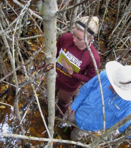
Technician Lorae Simpson and intern Jake Bodart deep in the mangroves, assessing vegetation cover and substrate color. (Mayda Nathan)
It sometimes seems crazy to be climbing through mangrove stands and wading through large ponds to collect our data, but the sites we explore are chosen for a reason. That reason is two-fold: One, to ground truth satellite imagery so we can map historic and current mangrove distributions. Two, to document the plant communities in places dominated by mangroves, in places where mangrove encroachment is occurring, and in places where mangroves have not yet arrived.
By using satellite imagery from years past, we hope to determine how far mangrove communities have spread in the last few decades. To do this we have to first understand what individual plant species comprise the large areas of vegetation that we can see from the satellites.
That is where we come in, climbing through mangroves.
At each site we go to, we take along a current satellite image of the area and target plots that represent dominant vegetation types for that site. Once we get to these plots, we record the plants we see and their percent cover – the proportion of the plot that their leaves and stems cover. The amount and type of plant canopy cover affects how the plot looks on the satellite image.
We also take note of other important variables that could affect the look of the satellite image, such as sediment type and whether the plot is in standing water. By understanding exactly what comprises the different spectral patterns of vegetation that can be seen on satellite imagery, we can determine the make-up of plant communities that we have never been to.
Another important piece of this project is determining how plant communities change as mangroves move in. We are tracking the spread of mangrove habitats up the east coast of Florida, as they have begun to appear farther and farther north. This means that the plant communities in the south have had mangroves for many years, but they are newer to the plant communities farther north. This allows us a unique opportunity to collect species composition data from a site where mangroves have been established for a very long time, and comparing it with data from a site where mangroves are relatively new.

Woody mangroves dominate tropical and subtropical coastlines; herbaceous salt marsh dominates more temperate coastlines. The shaded region represents the transition zone, which is thought to be shifting toward the earth's poles due to climate change. (Ilka Feller)
Ultimately we’ll be analyzing these data to test hypotheses about how mangrove encroachment will affect community composition, nutrient cycling and other fundamental ecological attributes and processes. What happens to the rest of the ecosystem when the dominant primary producers – the plants – make the dramatic switch from grasses to woody shrubs and trees? If the expansion of mangroves really is driven by a warming climate, what can we expect our southeastern coastlines to look like in the future? Will they continue to provide the same ecosystem services to coastal communities, even though marshes are replaced by mangroves?
Although wading through deep mud ponds and getting spider-web facials in the trees may not seem like an ideal work environment, to our team it means a successful day of learning more about mangrove ecosystems and how they are responding to global climate change.
More stories from the mangroves >>
Nancy Shipley is an intern with the Smithsonian Environmental Research Center and undergraduate student at New College of Florida.This material is based upon work supported by the National Science Foundation under Grant Number 1065098. Any opinions, findings, and conclusions or recommendations expressed in this material are those of the author(s) and do not necessarily reflect the views of the National Science Foundation.


