by Kristen Minogue
On a hot afternoon in July, a team of researchers sailing down Chesapeake Bay stumbled across a cluster of striped bass floating in the water. About a dozen of the iridescent black and silver fish bobbed at the surface near the ship’s bow. All of them were dead.

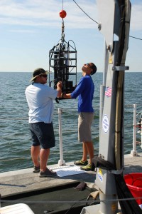
Scientists prepare to measure how light interacts with particles in the Bay. Credit: Carlos DelCastillo
The fish kill came out of a low-oxygen zone near Annapolis, just one symptom of the Bay’s declining health. Overflows of nutrients from farms and cities have fueled massive growths of algae that cut off light and oxygen to the Bay’s lower levels.
“There was a very quiet moment between everybody on the boat,” recalled Vienna Saccomanno, one of the Smithsonian research interns aboard when it was discovered. “You kind of knew what everyone was thinking, feeling empowered to continue with this research and hopefully contribute to prevention of this in our water system.”
The scientists on board weren’t there simply to document the Bay’s many ailments, however. They had joined the 10-day cruise to pave the way for a much larger goal: a geostationary satellite that could provide constant, detailed coverage of coastal health.
Click to continue »


